Compute Altitude
The elevation gain of a tour varies between different devices and this programm which has it's own algorithm to compute this value.
When the whole tour is acending up then it's the easiest way to get the values. But when a tour is also going up and down for several times or when the surface is almost flat, then it's not that easy. It also depends on the device which is recording the data, it's accuracy and resolution.
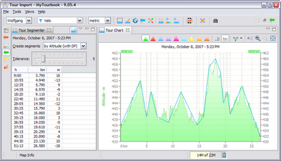
With the tour segmenter it easy to find the correct value by changing the tolerance to approach the altitude graph and getting the elevation gain.
The above tour in the tour segmenter (which circumnavigates a sea) ilustrate the different values, but which is correct?
Tolerance 5 and 6 have almost the same value as HAC5 but the peaks at km 8-9, km 18 and other smaller peaks are ignored which results in a too small value for this device.
Tour Segmenter
|
Tolerance |
EG* |
|---|---|
|
0 |
147 |
|
1 |
124 |
|
2 |
102 |
|
3 |
91 |
|
4 |
86 |
|
5 |
74 |
|
6 |
74 |
|
7 |
66 |
|
8 |
55 |
|
|
EG* |
|---|---|
|
HAC 5 |
75 |
|
Adjusted Altitude with MyTourbook 9.05 |
117 |
Same tour with HAC4
|
|
EG* |
|---|---|
|
HAC 4 |
103 |
|
Adjusted Altitude with MyTourbook 9.05 |
110 |
*Elevation Gain in meters


