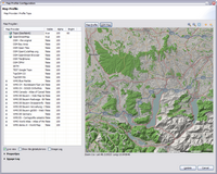
Profile Map Provider
A profile map provider can display a map which is composed with several custom and wms map providers.
This dialog can be opened from the map provider management dialog by selecting a profile map provider and pressing the Edit button or double clicking the map provider.
Map provider list
This list contains all custom and wms map providers which are installed in the application.
Activate map provider
A map provider must be activated to see the tile images in the map, this is done by setting the map provider visibility state in the map provider list. There are several ways to toggle the visibility of a map provider:
Custom map provider
- double click a map provider
- space key
- mouse click in the Visible column of a map provider
WMS map provider
To make a wms map provider visible in the map, at least one layer must be made visible. The layers are children of the wms map provider in the hierarchical map provider list. Toggle the visibility of the wms map provide with:
- double click a layer, this will automatically set the map provider visibility
- space key
- mouse click in the Visibility column of the layer/map provider
Actions
|
Map Profile |
Displays the tile images in the map from the composed map providers |
|
OSM Map |
This action toggles the tile images between OpenStreetMap and the profile map provider. This feature is helpfull to navigate to the location and zoom level where the profile map provider provides tile images. |
|
|
Displays the map at the favorite location and zoom level |
|
|
Sets the current location as the favorite location |
|
Live View |
When enabled, all modifications in the map provider list or modifications of the selected map provider will be displayed immediatedly in the map. When disabled, any modifications will be displayed in the map when the button Map Profile is pressed. When a tile is being loaded, the loading... message will only be displayed when Live View is disabled. |
|
Show tile detail/errors |
Displays the tile position and border of the tile. When loading of a tile image failed, en error is displayed. |
|
Image log |
When checked, loading of the tile image is logged in the field Image log: |
Fields
These fields are visible when the section Properties is expanded
|
Zoom Levels |
Defines the zoom levels for which the map provider supports tile images |
|
Image background color |
This background color is displayed in the map when all visible map providers have a transparency or when no map provider provides tile images at the tile position |
|
Image log |
is documented here |
Map Provider Actions/Fields
These actions are visible when the section Properties is expanded
|
Apply brightness to the next map provider |
When checked, the brightness from the current map provider is applied to the next visible map provider which is below the current in the map provider list. The current map provider must be made visible in the map to enable this feature. This feature can apply the brightness of a relief to another map to see the map in a more realistic shape. |
|
Alpha transparency |
This feature is enabled when brightness is disabled. Set transparency for the selected map provider: 0 ... map provider is transparent 100 ... map provider is opaque |
|
Transparent colors |
This feature is enabled when brightness is disabled. When checked, up to 21 colors for the selected map provider can be set to 100% transparent. |
|
Black is transparent |
When check, the color black is transparent for the selected map provider |


