

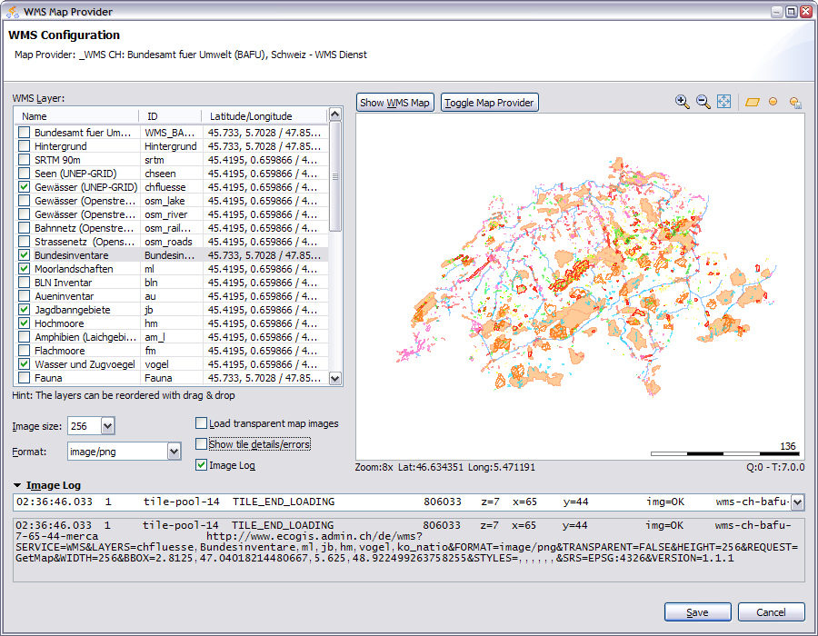
WMS Map Provider
|
|
This map provider can display tile images from a WMS (Web Map Server).
It was not intended to create a full fledged GIS because this would be totally out of scope for this kind of application.
This dialog can be opened from the map provider management dialog by selecting a wms map provider and pressing the Edit button or double clicking the map provider.
Limitations
- the projection which is currently supported is EPSG:4326
- only the image size of 256 pixel is supported when the wms map provider is used within a profile map provider
Fields
|
WMS Layer |
All layers which the WMS provides are listed here. The checked layers are displayed in the map according to the sequenz of the layers. The layers can be rearranged with drag&drop in this list. |
|
Image Size |
sets the url parameter WIDTH and HEIGHT to the selected size |
|
Format |
sets the url parameter FORMAT according to the selected format |
|
Load transparent map images |
sets the url parameter TRANSPARENT=TRUE or FALSE |
|
Show tile details/errors |
Displays the tile position and border of the tile. When loading of a tile image failed, en error is displayed |
|
Image log |
When checked, loading of the tile image is logged in the field Image log, this is documented here. This feature can be very helpfull to see the communication with the wms server like when nothing is displayed in the map or when something is displayed which was not expected. |
Actions
|
Show WMS Map |
Displays the tile images in the map from the wms |
|
Toggle Map Provider |
This action toggles the tile images between OpenStreetMap and the wms map provider. This feature is helpfull to navigate to the location and zoom level where the custom map provider provides tile images. |
|
|
Displays the the whole area of the selected layer which is defined in the Latitude/Longitude column |
|
|
Displays the map at the favorite location and zoom level |
|
|
Sets the current location as the favorite location |
Connection problems with a WMS server
There can be many :-(
Sometimes the WMS server fails and returns an error Information only in a html page which the geo toolkit (which is used to communicate with the wms) do not recognize. Try to open the request url in the browser to see the information which the wms server returns.
Such a message can look like:
msLoadMap(): Premature End-of-File. msyylex(): Unable to access file. Error opening included file "/var/www/mapfile-include/map.outputformat.map".
